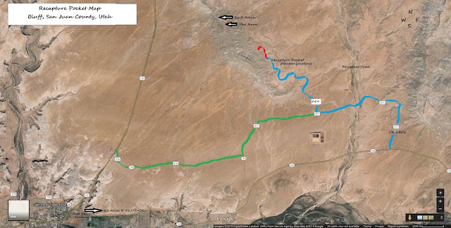
Recapture Pocket is an area of badlands near Bluff, Utah;
like Goblin Valley, it is a sand filled landscape with hoodoos of all shapes
and sizes.
· Location is 54.1 miles from Monticello; travel
45.9 miles along Hwy 191 to the junction of Hwy 162 in Bluff (Cow Canyon
Trading Post on SE corner). Start at the
Trading Post to be able to get to the 4.9 mile mark, not at the sign that says
“Mile 0”. The road to make a left on has
2 names when looking at an area map (CR 2401 and CR 217), there will be a
yellow “cow sign” with a “cattle crossing” sign underneath it, make the
immediate left. If a 2nd cow
and cattle crossing sign are passed, you have gone too far. After the initial left turn, there will be a
split 9/10ths of a mile in, take the left hand split and go 4/10ths of a
mile. Make a right turn onto CR 249
(Bluff Bench); another split will be reached at 7/10ths of a mile, go left
again. Hoodoos (unusual sandstone
formations) will be seen, but it will be 1.3 miles before Recapture Pocket
itself is reached.
·
Admission: Free
·
Difficulty: Hiking – Easy; Vehicle: This area is
completely desert terrain; 4-wheel drive vehicles will need high clearance due
to deep dips on sandy trails and some travel over rocky ground.
·
Camping: Yes; pack out what is packed in.
·
Facilities: None; nearest town (Bluff) is 8.2
miles.
·
Pets: Allowed, owners are expected to clean up
after pet (s).
·
Caution: Flash flooding will occur over roads
during long and/or torrential rainstorms; once water recedes, sandy trails will
be extremely muddy.
Mary Cokenour


No comments:
Post a Comment