Pages

Friday, August 30, 2019

Travel Guide to Mexican Hat Rock.


Mexican Hat Rock was so named due to the resemblance to an upside down Mexican sombrero hat.  Walls along the San Juan River have a design woven through them with varying colors of reds and purples.  The Navajo call it "Mountain That is Coiled"; the design is used by weavers and called "Navajo Blanket".  It represents the giant bullsnake or “Great Serpent” that lives inside; bad luck comes to those who trespass or do not treat the hills with proper respect.


          Location is 69.3 miles from Monticello; travel 50.7 miles along Hwy 191 until it changes to Hwy 163 west of Bluff; travel for 18 miles and there is either a road side pull-in to view Mexican Hat Rock, or make the left turn onto a maintained dirt road, it is 6/10ths of a mile to the base of the formation.


          From the base of Mexican Hat, follow the dirt road around to the right and it will continue down to the San Juan River.

          The formation is accessible year round.

Mary Cokenour

Thursday, August 29, 2019

In Search of Sand Island's Mammoths - Part Two

It is almost a year since I wrote about the mammoth carvings at Sand Island In Search of Sand Island's Mammoths - Part One .  2018 was not a very good year for either Roy or myself; illness, financial hardship; issues with people who, in general, were simply reliving high school as the "mean clique".  2019 was dubbed the "Year of Fresh Starts", and it certainly has been for the most part.  Recently we both were given fresh starts with employment, and now have time for each other, and important aspects of our lives that kept getting pushed aside.  Basically, we are back on the road to wellness; wellness in mind, body and soul.  Enough boring talk, let me get onto telling you about Sand Island's Mammoths.

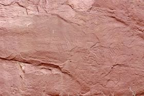
It was one week, after our first attempt at mammoth hunting, that we returned to Sand Island , determined to find the other mammoth.  This time we had a copy of a photograph which showed the carvings and other rock art colored in.  It would help us go back to the first mammoth which was more visible, and follow the rock art along the wall to the second mammoth. The pock marks simply look like weathering over time; the colored in photo shows how the marks were interpreted.  Easier said than done as this wall is very pock marked, so even with a zoom lens, finding the figures was still difficult.

Many of my photos are repeats from Part One, just taken in a different light; it was a cloudy day this time.  People often think that going adventuring is determined by the weather.  No, it is determined by how much one wants to do the adventure.  As you read through this travel blog, you will notice that Roy and I have visited places on sunny days; in snow, rain, cloud cover as well.  However, we are smart enough to know the dangers certain weather conditions can bring, so we won't be in areas of possible flash flooding, and no mud fests for us!

The trail to the carvings, and other rock art, is at the last camp site, along the same rock wall as the ranger station.  Yes, people might be in that camp site; just be polite, say hello, and keep walking to the log posts that indicate the start of the trail.  Now don't go wandering through someone's camp site to get there.  Park at the ranger station, walk along the trail for vehicles, and you'll see those log posts at the end of it.


You will have to walk downward just a few feet, but then the trail evens out, and it is an easy walk for a half mile where it meets the San Juan River.


The rock art show begins almost immediately, and there will be other interesting sites along the trail.  Keep those eyes open, cameras at the ready!


 Warning:  if you are easily offended, don't look at these humanoid figures too closely.  Their gender is definitely expressed in the drawings.


 Men on horseback, wearing hats?  The Spanish came through San Juan County, then came the Colorado and Texas ranchers, and finally the Mormon pioneers.


Unfortunately, you will come across "idiot markings".  Pristine sandstone walls, or ancient rock art itself, marred with initials, names, drawings from 20th and 21st century humans.  Why?  Well that's why I call them "idiot markings", the people who do this are, and I'm being nice here, idiots.  They seem to think that all rock art is just graffiti, so no one will care if they add to it, right?  Wrong!  Oh, and please don't give me the argument of, "Well, they didn't know better."  That's a huge load of bs right there; information is available online, on informational boards at sites, and basically every visitor center and museum in the 4 Corners region.  Ignorance is definitely no excuse! The ancient rock art/drawings are how these people communicated, left messages for others, wrote out their own history.  Modern man used paper, ink, pens; created bound books; and nowadays the written word of any language can be found digitally.  So, look, take photos, admire, but don't touch!
Human heads are NOT ancient drawings.
Back to the real art work of Sand Island...

Post holes in the wall; wooden logs would have been placed inside.  There could have been a platform to stand or rest on while the drawings were created.  There could have been some other type of structure there, using the logs for support.


Carving of a large male deer or elk.


There are carving marks on this fallen stone. 
Center left, looks like a horse


I found these next drawings to be truly interesting.  The triangle shaped humanoid is indicative of the Fremont culture, with similar drawings found in Shay Canyon, Capitol Reef and Nine Mile Canyon.


The humanoid figure with the long fingers and toes is similar to the figure found at the Wolfman Panel, found in Comb Ridge.  (Yes, I've written about these sites, just use the Search box on the upper right of any blog page and prepare to have your mind blown!)


So I mentioned there would be other aspects of Sand Island to see and admire.


Beehive Box in a tree.

Bees are pollinators, so need to be protected.


Huge Claret Cup Cactus hanging off a ledge.

At this point in time, you're wondering, "Where are the mammoths!?!"  Well, like any Travel Channel show or documentary, there is the tease at the very beginning, but you have to watch the whole telecast to get to the really good part.  Speaking of Travel Channel, I did contact them about using my travel blog, about the 4 Corners region, as a show idea.  Nah, they only use ideas from their own staff...their loss!!!

...and now the mammoths.

You will know you're in the correct area due to the wooden post fencing around this area.  First off, they don't want anyone climbing up to the rock art due to the unstable nature of the rocks and sand.  Second, they definitely don't want anyone up close and personal touching the carvings and drawings; they're already weather beaten down enough.  The acidity of the human hands will only cause further destruction, never mind the "idiot markings".

Fallen sandstone, what rock art might have been here?


Mammoth #1
Arrow indicates Mammoth #1

Mammoth #1 Outlined


Mammoth #2

Supposedly there is a bison carving overlaid on the mammoth.  After I outlined the photo, the small head looks more like a deer or elk, not a bison.  Then again, I'm no expert.


Mammoth #2 Outlines
...and there you have them, the Mammoths of Sand Island.

Whether you decid to camp at Sand Island, or just visit, enjoy the journey!

Mary Cokenour


Wednesday, August 28, 2019

Edge of the Cedars Travel Guide.

Edge of the Cedars State Park Museum is not a park that permits camping or activities as allowed in a public park.  It is an Ancestral Puebloan archaeological site, museum & archaeological repository. 


Outdoor park facilities include a short, paved interpretive trail around the ruin, landscaping with native plants and outdoor sculptures, and picnic area.

Location is within the town of Blanding; 21.3 miles south of Monticello along Hwy 191 for 20.1 miles, right onto Est 200 North, right onto North 400 West, left onto West 400 North, right to access parking area.


Open March – November (except Thanksgiving Day), Mon-Sat, 9am-5pm, Sun 9-4pm; December - February (except Christmas Eve & Day, New Year’s Eve & Day), Mon-Sun, 9am-2pm.

Restrooms, water fountain, gift shop inside.

Admission Fee: Yes

Camping – Not allowed.

Pets – Not allowed.

Website: https://stateparks.utah.gov/parks/ (scroll down to Edge of the Cedars box)

Address: 660 West 400 North, Blanding, UT, 84511

Phone: (435) 678-2238

Edge of the Cedars is also part of the Four Corners Lecture Series.  We've enjoyed many an afternoon listening to educators on pottery, weaving, rock art, geology, native plants, foods and life in general in the 4 Corners region of the Colorado Plateau.

Mary Cokenour

Tuesday, August 27, 2019

Mule Canyon's Cave Towers Travel Guide.

Cave Towers, also referred to as Mule Canyon Towers or The Seven Towers, is named for seven large Anasazi, or Ancestral Puebloan, stone towers that were built around 1200AD at the head of a deep gorge.  It is speculated that they are a defensive position protecting a spring in Cave Canyon, as well as granaries and puebloan ruins along ledges.


Location is 43.9 miles from Monticello; take Hwy 191 south into and through Blanding, 24.6 miles, until the junction of State Hwy. 95, make a right onto Hwy. 95 and travel 19.3 miles.


Make left turn onto dirt road that has a gate across it; open gate, close after passing through. Travel 4/10ths of a mile to reach a parking area with information board. Access to trailhead is 4/10ths of a mile further along a dirt and slickrock trail that can be hiked, or accessed by 4-wheel drive vehicles with high clearance only.

Round trip walking distance to ruin sites is 1.6 miles; walking slickrock at canyon’s rim, granaries and pueblo ruins can be seen along the canyon’s ledges.  Approximate visitation is 1-2 hours.

Difficulty: Easy; there is a steep walk to tower ruin on right side of trail.

Facilities: None

Admission: Free

Camping: Allowed, check informational board at parking area for locations.

Pets: Allowed, owners are expected to clean up after pet (s).


Walking along the ledges, looking out at the Pueblo ruins, and the surrounding scenery, is mind blowing.

Mary Cokenour

Monday, August 26, 2019

Dinosaur Museum in Blanding Travel Guide.

At The Dinosaur Museum, the complete history of the world of the dinosaurs is presented. Skeletons, fossilized skin, eggs, footprints, state-of-the-art graphics, and beautifully realistic sculptures present the dinosaurs from the Four Corners region and throughout the globe.


Location is at the southern end of Blanding; 21.4 miles south of Monticello, along Hwy 191 for 21.3 miles, right turn onto 700 South & left onto South 200 West to access parking area.


Open April 15 – October 15, Mon-Sat, 9am-5pm, Closed Sunday.

Admission Fee: Yes.    Special group rates are available for tours of 10 or more persons.
                                      Guided group tours are available with reservations.

Camping: Not Allowed.

Pets: Not Allowed.

Website: http://www.dinosaur-museum.org

Address: 754 South 200 West, Blanding, UT, 84511

Phone: (435) 678-3454

From the youngest child to the oldest adult, if you are fascinated by dinosaurs, don't miss this museum!

Mary Cokenour

Sunday, August 25, 2019

Nations of the Four Corners/Nations Natural Bridge/Westwater Ruins Travel Guide.

Nations of the Four Corners is a cultural center honoring those who added to the history of the area: Ute, Navajo, Hispanic, and Pioneer.


Location is within the town of Blanding; 21.1 miles south of Monticello along Hwy 191 right onto West 500 South, go 6/10ths of a mile to access parking area.


Five (5) mile loop hiking trail (maintained gravel/dirt) featuring replicas of Pioneer, Hispanic & Native American home life; an observation tower and Prayer Arch.

There is also a five (5) mile loop trail (dirt/rock) to the overlook of Westwater Ruins aka Five (5) Kiva Pueblo & to the one (1) Natural Bridge.

Open year round; open to school field trips, general public & tourists.

Admission: Free.

An across the canyon view of the Natural Bridge & Westwater Ruins is located on West 1600 South.

Website: https://www.sanjuanfoundationutah.org/

Address: 580 South 650 West, Blanding, UT, 84511

Phone: (435) 678-4000


Nations of the Four Corners/Nations Natural Bridge/Westwater Ruins

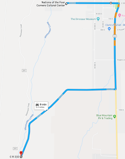
Location: From Nations of the Four Corners, go east on 500 South to return to Hwy. 191 (6/10ths of a mile), make right onto Hwy.191 to go south to 1600 South (USU Trucking School on corner) (1.1 mile).  Make right onto 1600 South.  The paved road dead ends at Utah Department building; continue onto dirt/gravel road to the left (CR 232 aka Ruins Rd.).


Nations Natural Bridge


Travel 1.2 miles to a pull-in for Nations Natural Bridge; there will be a sign indicating the Natural Bridge.

Westwater Ruins aka Five Kiva Ruins


Westwater Ruins aka Five Kiva Pueblo is an outstanding example of ancestral architecture of a cliff dwelling that was occupied about 750 BC to 1275 AD.  Although inhabited from Basketmaker to Pueblo III, the current set of ruins is primarily Pueblo III.  The broad flat plaza of the main central area is the location of the kivas; storage and housing rooms are the room blocks seen behind.  A natural spring in the canyon would account for why the ancestral Puebloans chose this area to reside in.

Continue along road to Westwater Ruins aka Five (5) Kiva Ruins; keep an eye on the canyon walls to the right of the road as there are granaries tucked into it.  The road dead ends at an unpaved parking lot (5/10ths of a mile from the natural bridge), Westwater Ruins can be seen across the canyon, facing northward.  There is a steep, yet easy to hike, trail (dirt & rock), downward to the edge of the canyon face where an unobstructed view of the ruins can be seen.

Total mileage from Nations of the Four Corners to Westwater Ruins is 3.4 miles.

Nations of the Four Corners also has picnic areas, so pick up a meal and enjoy the scenery.

Mary Cokenour