 Back on January 25, 2015, I wrote about our first visit to the Cottonwood Millsite on South Cottonwood Road (CR 228). On the posting I showed a satellite map image of the area; we had visited the upper portion of the millsite only; now it was time to go back and check out the lower section. We also inspected CR 274 which is separated into three different trails; 4 wheel drive for the most part, but ATV riders were out aplenty that day.
Upper Cottonwood Millsite
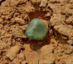
If you look at the satellite image, you would believe that the lower section was directly across from the upper section on CR 228, but not so! After walking around the flat ground, finding a stray brick or two, we decided to see what was on the first trail marked CR 274. We had only gone a quarter of a mile when Bingo!, there it was, the other, or what I call the lower, section of the Cottonwood Millsite. For some unknown reason, this section seemed to be more "mysterious", for lack of a better word. Maybe it was the grouping of bricks that almost looked like a fireplace or kiln; maybe it was the other groupings of stones that resembled Indian ruins (we did find a few pottery shards on the ground). Then there was the green coloring coating many of the bricks or natural stonework; was this residue from the processing of uranium? Except from the occasional roar of ATV motors, the area was dead quiet which added to the air of mystery.
Lower Cottonwood Millsite
 |
| View of CR 274 from the Millsite |
Bricks Used
.JPG)
.JPG)
Green Coloring on Stones
 |
| Pottery Shards |
.JPG) So now it was time to find the mines; we knew they had been closed down, but were they buried over? We didn't have to travel far before seeing some debris, and the large stones that closed off the opening to what was probably a mine shaft. This first CR 274 trail ended quickly for us; it became better suited for ATVs.
So now it was time to find the mines; we knew they had been closed down, but were they buried over? We didn't have to travel far before seeing some debris, and the large stones that closed off the opening to what was probably a mine shaft. This first CR 274 trail ended quickly for us; it became better suited for ATVs.
Across from this trail was another one marked CR 274; well of course we explored it. We found some debris, but it was mostly scenic, a nice ride, but a deep stream prevented us from continuing on to CR 228 which we could see ahead. So close, yet so far; a turn around was the only answer though.
 Backtracking towards State Highway 95, the third trail labeled CR 274 was way more interesting when it came to learning about the mines. We investigated two; both had iron gates closing off the entrances, but deep enough to get a good view inside.
 Mine #1
.JPG)
Mine #2
.JPG)
.JPG)
 |
| Bottle wedged into mine wall; a final toast farewell? |

Skeletal Remains of Mining Equipment

As you hike or drive around this area, you will see many a rubble pile; these piles are an indication of where the uranium tailings once laid. Once the Cottonwood Millsite closed down, the tailings were collected and sent to the new Monticello Millsite. Eventually, once the dangers of uranium and vanadium were discovered, these areas were thoroughly cleaned up. They are checked every five years to make certain there is no radiation being emitted.
The uranium and vanadium mining era in San Juan County is part of the county's factual history. If you would like to learn more, Blue Mountain Shadows Magazine did several issues dedicated to mining history. "Mining in San Juan County" volume 16; "Cottonwood Mining" volume 25; "Cottonwood Mining #2" volume 26; "Cottonwood Mining #3" volume 27.
Mary Cokenour
.JPG)
.JPG)
.JPG)
.JPG)
.JPG)
.JPG)
.JPG)
.JPG)
.JPG)
.JPG)
.JPG)

.JPG)
.JPG)
.JPG)

.JPG)
.JPG)

.JPG)
.JPG)
.JPG)
.JPG)
.JPG)
.JPG)
.JPG)
.JPG)
No comments:
Post a Comment